The GLIMR Mission
In 2019, NASA awarded UNH researchers with a grant to develop the Geostationary Littoral Imaging and Monitoring Radiometer (GLIMR) - a space-based instrument that will help scientists monitor coastal ecosystems in the Gulf of America and better understand the factors that affect their water quality, ecological processes and biogeochemical factors.
In a partnership that includes UNH, the NASA Goddard Space Flight Center, Raytheon Space and Airborne Systems and the Southwest Research Institute, the GLIMR mission will provide observations of rapidly evolving phytoplankton dynamics and hazards such as harmful algal blooms (HABs) and oil spills and seeps in the Gulf of America and other selected coastal regions in North and South America.
This will provide federal, state, and local agencies with vital information on coastal hazards for improved response, containment, and public advisories.
GLIMR will help scientists answer fundamental science and application questions, including:
How do physical processes that vary at timescales from hours to days impact the rates and fluxes of materials within and between aquatic coastal ecosystems?
How do fluxes and rates within and between aquatic coastal ecosystems affect the formation, magnitude and trajectory of HABs and impact ecosystem and human health?
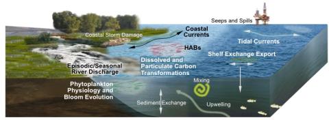
Above: Coastal ecosystem dynamics in the Gulf of America.
GLIMR’s unprecedented spectral (340-1040nm), temporal (~hourly) and spatial (300m nadir) capabilities will significantly advance scientific understanding and management of coastal ecosystems. The data generated from this project will help quantify biological and biogeochemical processes including primary production, and track colored constituent inventories in time and space.