Earth Sciences, Ocean Mapping M.S. '22
 Nautilus.")
Alumni Spotlight Q & A:
Where are you from, Erin?
Minersville, Pennsylvania. I did my undergrad at Slippery Rock University of Pennsylvania.
What did you study and who was your adviser?
M.S. Earth Sciences, Ocean Mapping. I just officially graduated in May 2022. The Ocean Mapping curriculum is pretty set to prepare you for a career in ocean mapping utilizing multibeam sonar; I took (or audited) additional classes focusing on geology and oceanography when I could fit them in to my schedule. My adviser was Larry Mayer.
Why did you choose UNH?
I chose UNH specifically because of the Center for Coastal and Ocean Mapping (CCOM) and for the Ocean Mapping M.S. option. I came to a career in ocean mapping in a roundabout way. I'd studied geology and GIS as an undergrad (major Environmental Studies with minors in Geology and Geographic Information Technology), and my first job after undergrad was with the USGS in Woods Hole, MA. I was working for a scientist, Page Valentine, who was doing seafloor habitat maps. He hired me for my GIS skills, but as someone who studied in western Pennsylvania, I didn't know much of anything about marine geology or how the seafloor was mapped. I started learning about ocean mapping there, and then went to work for a software company that specialized in software for processing and visualizing ocean mapping data (Fledermaus, now QPS Fledermaus and QPS Qimera). That brought me to their office in Portsmouth NH, and as part of that job I met Larry Mayer and many other researchers at CCOM. I would also do software training for the incoming Ocean Mapping students at CCOM each year. After a while I realized I wanted to gain a better understanding of the acoustics and other systems that are part of ocean mapping, so I decided to apply to the program.
What were your favorite courses and why? Which professors had the greatest impact on you?
So many favorite courses! I loved Physical Oceanography with Jamie Pringle – it was my first exposure to physical oceanography, and I felt like lightbulbs were going off in my head all the time, realizing the reasons behind oceanographic phenomena. I was also at sea for the first few weeks of the course and Dr. Pringle was very supportive, recording and posting lectures for us to keep up on the class. Sedimentology with Joel Johnson brought me back to the joy of geology lab work and field trips, and every lecture was like the best story you ever heard. I also really loved the Physical Oceanography short course John Hughes Clarke did over J-Term, which really focused on the relationship between physical oceanography and ocean mapping, and Tom Weber's Acoustics course.
What was student life like? What did you think of the campus and extracurricular activities?
I returned to student life after working for over 10 years, so it was challenging. The campus is beautiful, and has a lot of opportunities for extracurricular adventures, but I didn't participate in extracurricular activities – well, except maybe head-clearing walks in College Woods near the Chase Ocean Engineering building, gym time at the incredible Hamel Rec Center, and long winter lap swims in the Field House pool.
What was the biggest transitional issue you faced when you started at UNH?
Going from working professional back to student! Many of my professors were colleagues in my working life, and then I had to go back to being a subordinate student. I'm going to be honest, I didn't like it. And I really missed reading for pleasure; I didn't have time for that during my first year back as a student.
What is your current position and location?
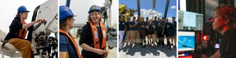
This is a fun one. I am an independent contractor, doing ocean mapping and GIS services. Most of my work is at sea, actively doing seafloor mapping, or 'data acquisition and processing' is how we describe this type of work. I contract to several different organizations, and it changes from year to year, but the group I contract with the most is the Ocean Exploration Trust, which owns and operates the Exploration Vessel (E/V) Nautilus. The E/V Nautilus maps the seafloor and water column with multibeam sonar, and uses ROVs (remotely operated vehicles) to explore the seafloor. They also often work with 'guest vehicles,' such as ROVs, AUVs (Autonomous Underwater Vehicles) and USVs (Uncrewed Surface Vessels) owned by partners who come on the ship to do exploration – we (myself included) began just such an expedition on July 15th, 2022, with a huge cohort from UNH CCOM and using their DriX USV in conjunction with our ship based multibeam sonar to do dual-operation seafloor mapping. The Nautilus is currently operating in the Central Pacific; the operating location depends on the year, and they have done work in the Mediterranean, Black Sea, Gulf of Mexico, Atlantic, and Eastern Pacific.
What does a typical day of work look like?
My typical day on Nautilus will differ depending on the expedition and my role on that expedition. I am often the Mapping Coordinator, which means I will oversee the mapping operations and lead the mapping team in mapping planning, acquisition, processing, and product generation; the ship is also an educational ship and we almost always have several interns, so as the Mapping Coordinator I will take the lead on mentoring the seafloor mapping interns. On ROV expeditions I may be the Mapping Coordinator, or I may be a Navigator or even the Lead Navigator. Navigators are part of the operations team during an ROV dive; they facilitate communication between the scientists, who have dive targets they want to reach and dive goals to attempt to fulfill, the ROV pilots, who are attempting to get the ROVs into position to visualize and sample the features of interest to the science team while doing so safely, and the ship Captain and Mates, who are piloting the ship to the locations where the ROVs want to go, while keeping an eye out for hazards like other ships or shallow waters. It is a fun dance, can be pretty intense sometimes, and it is one I learned while on Nautilus – as I said it is an educational AND scientific exploration ship, which extends to cross training folks who came on in other roles if they are interested.
I've learned how to assist with deck operations on Nautilus as well. These are opportunites that you don't get on most ships, when you come on in a science role. And on my last expedition I was a Co-Expedition Leader for the first time. The Expedition Leader facilitates the expedition, working with all of the onboard teams to make sure they have what they need to fulfill the goals of the expedition. They aid in the expedition planning, working with OET staff and the Lead Scientist(s) for the expedition, and once onboard they are moving between all of the teams including science, navigation and mapping, ROV, communications, and the ship's crew to keep things running smoothly – while also communicating the progress to partners on shore.
"What do I like best? I love all of it. The changing role, the daily surprises and challenges of oceanographic exploration, the flexibility to work from home on some contracts – it's really incredibly fun."
Do you work anywhere else? What do you like best? Why is your work important?
I also do similar work on other ships, including the NOAA Okeanos Explorer – many of the full-time Okeanos team also work out of UNH – CCOM! And I do home-based data processing and GIS work too, for many organizations that have included the University of Alaska and Columbia University Lamont-Doherty Earth Observatory. So, it's really hard to say what my day-to-day looks like, or the location. When I'm not on the ship I'm at home in Portsmouth, NH or Honolulu, HI. What do I like best? I love all of it. The changing role, the daily surprises and challenges of oceanographic exploration, the flexibility to work from home on some contracts – it's really incredibly fun. My work is important because it is supporting all kinds of scientific exploration, for all kinds of goals – we are mapping in completely unmapped areas (only about 24% of the ocean is mapped), and exploring and sampling for many scientific pursuits, with climate change being some part of almost every expedition I've been part of.
What are your future career plans?
I am really, really enjoying my current work and there is so much variety in it that it is hard to guess exactly what the future holds. I would like to gain more leadership experience and eventually see myself in a full time role with a strong leadership component, but I'm not ready to sacrifice the excitement of sea life to do that just yet.
Any advice for undergrads/grad students who are conducting research?
Learn how to code and take the math courses (if this applies to your field of study at all of course!). Don't be too hard on yourself and keep going. At some level, everyone is winging it.
What was something you would have changed about your graduate research experience? What can be improved so that other students conducting research have an improved experience?
I took way too long to finish. This was not the fault of UNH, my advisors, or department – I started going out to sea during graduate school and didn't want to stop, and I am happy they allowed me that opportunity and didn't try to stop me. It led to the amazing work I'm doing now, but it made it very, very challenging to finish my thesis work. If at all possible, really try to focus on your degree-related research and get it done. It will just be easier in the long run!
Are you on social media? Do you have any links to share?
The Nautilus handles:
Some additional video links:
- How We Use Seafloor Mapping Data to Guide ROV Exploration!
- Beyond the Wow: Launcing and XBT
- Ocean Exploration in the Lakes – 2021 Expedition Update (includes other UNH folks too)
- Sampling Low Oxygen Environments of the Santa Barabara Basin and West Coast EEZ Mapping
pursue a degree in Ocean Mapping
Are you or is someone you know an alum who conducted research with us? Want to be featured in an upcoming Alumni Spotlight? We'd love to connect! Please email Rebecca.Irelan@unh.edu with details.
SHARE